The trail less traveled
- mynnyadventures
- Mar 6, 2022
- 7 min read

What a beautiful March day, partly sunny and a high in the mid thirties. A perfect day to head out to the mountains. After hitting the drive thru and the gas pump I decide to head south east today. My destination, Owl’s Head Mountain. An hour and ten minutes of following my GPS and the All Trails app I came to the sign: No Trespassing and No Parking. The app says drive past the sign under the power lines and the parking lot is on your left. One major problem with this was the 6’ tall 15’ wide snowbank in the way. As I sat there at the snow plow turn around area pondering my options, I watched no less than 30 snowmobiles scream by me. It was great to see these sleds on what looked like a four lane highway for snowmobiles. What a trail system, I thought to myself, kind of wishing I had a sled at that moment. But today was about mountain climbing for me. Lucky for me there was plenty of cell service at this spot in the Adirondack Park so I clicked back into the All Trails app to see what else was in the area. A quick search and I found another trail about five miles away and headed off to the High Falls Trail.

Following the GPS down an old logging road I creep past a logging site to what looks like a trail head. As I arrive at my destination I see it is now being used as a snowmobile trail. Awesome, another sled trail, this is pretty impressive, I thought to myself. These folks have this figured out. This trail system has to be amazing. One more time back on my app I went looking for one more place. The app reveals a mountain about ten minutes away. Ok, let's try this again. Ten minutes later my phone tells me I’ve reached my destination. There isn’t much out here on this back road in the middle of nowhere. Just two cars pulled off the side of the road. No big DEC sign, no obvious trail markers or anything that looks like a trail, so I get out and take a quick look around. In the snow bank across the road I can make out a few prints in the snow that have been almost completely washed away by the plows and one small and very odd trail marker for what must be Baldface Mountain.

I strap on my snowshoes, grab my ski poles and throw on my backpack. My first obstacle is to get up over the three foot snowbank on the side of the road. If you have ever done this in snowshoes before you know there is no graceful way of doing this. Just dig in and hope no one is watching because your chances of face planting in the snow is very likely. It wasn’t pretty but I made it over the snow bank and moved my way over to what I assume is a trail marker. Taking a closer look at this marker on a tree I see it is a 3D face painted bright yellow. Strange but it’s something. Just past this tree into the woods I can make out a faint set of tracks in the snow.

It looks like it's been a while since anyone has been here. I follow the tracks thinking I will come to a DEC sign-in box on the trail soon. Up the trail I go and by up, I mean steep incline up. After 100 yards of climbing I realize there is no sign-in box for this trail. Not a big deal as there are many smaller mountains in the ADK’s that don’t have them. I stop for a quick breather and look around for a trail marker. Not a marker in sight, just the faint tracks of what looks to be ski tracks. Kind of rough terrain to be skiing on but at least it’s something to follow. I pull out my phone to check my hiking app and it shows I am on a trail, so up I go. Step by very slow step I break out a trail in the snow. My legs burning and my lungs begging for more oxygen I slowly gain elevation. Once in a while I can still make out what appears to be ski tracks. I can’t even imagine having skis on this mountain.

Forty five minutes into this adventure I am over half way up and still not a trail marker anywhere. Just the view of mountains and lakes off in the distance. A true “middle of nowhere” experience.

Alone on a mountain, breaking a fresh trail isn’t for everyone. It’s a strange dichotomy, you curse and swear every step of the way. Your legs ache, your lungs burn and you ponder why the hell am I doing this, but then you also feel a sense of calm and tranquility knowing you are doing something you love. Being one with nature is very peaceful. My last push to the summit takes me another 15 minutes. I brush past the short pines to the open peak. Stunning view of the Adirondacks covered in snow surrounds me.

In the distance stands Whiteface Mountain. It’s towering design is very unique and easy to recognize. I spend 20 minutes taking pictures and soaking in the stunning views. It’s not very often these days you get to be alone on top of a mountain in the Adirondacks but somehow I pulled it off today.

Heading down the mountain is much quicker than going up. What took me an hour and a half to climb only takes me 25 minutes to come down. Being very cautious not to slip and fall on the steep terrain is challenging in many locations. Being alone can be exciting but dangerous as one wrong step can mean disaster in a hurry. Through the trees I can finally make out my truck on the road. Back over the snowbank I go and notice there are two more cars here now. Two young men are getting packed up to head up. I chatted with one of these guys for a few minutes. I told him I’d broken out a pretty good trail for him and it would be easy to follow since there are no trail markers. He said “ Yeah, I know there are no trail markers on this trail, just the yellow face, I come here often”. I said “ The only way I found this was with the All Trails App”. He said “All Trails has been a blessing and a curse, this hidden gem has been here for years with very little use”. He leans into the back of his truck and pulls out a snowboard. He said ”We have been coming here for years to backcountry downhill ski and snowboard. Now that the climbing apps are available we see a bit more activity here.” I apologized and said “I hope my tracks didn’t ruin any of your snowboarding trail”. He replied “No worries at all, there is a lot of this mountain to share and a few more people using it will only make it better.” As he put his snowboard on his back and strapped into his snowshoes I wished him a safe adventure and climbed into my truck to head home. On my way home I pondered the conversation I had on the side of a mountain road with a stranger in the middle of nowhere. “There is a lot of this mountain to share,” what a great statement. Thinking back to my original plan for the day, I could have been upset that my first spot didn’t work out because of a snowbank and a huge snowmobile trail. Option two again was unsuccessful due to another snowmobile trail. But I didn’t get upset, instead I was excited to see the terrain being used. There are three other seasons I can get on these trails. It’s great seeing people of all walks of life finding their own ways to enjoy the great outdoors. If we respect each other and work together to keep our trail systems clean and maintained there truly is enough mountain to share.
About this location:
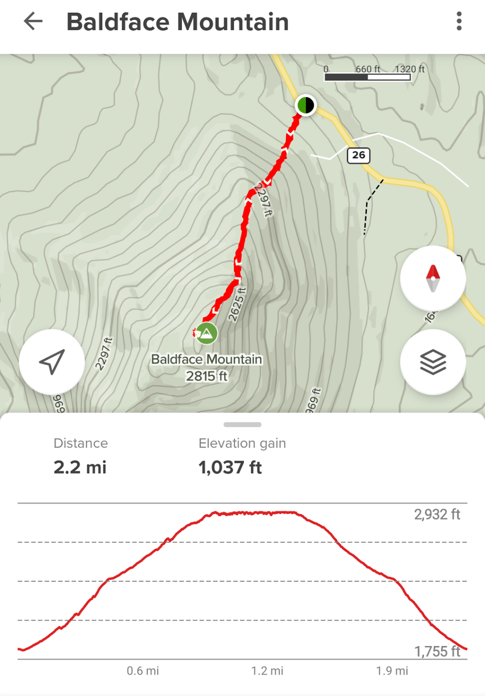
Baldface Mountain is located on county route 26 in Franklin County. It is about an hour and twenty minutes south east of Massena and about a half an hour south of Malone. If you look on a map it sits just to the west of Debar Pond about 3-5 miles south of Pond Rd.
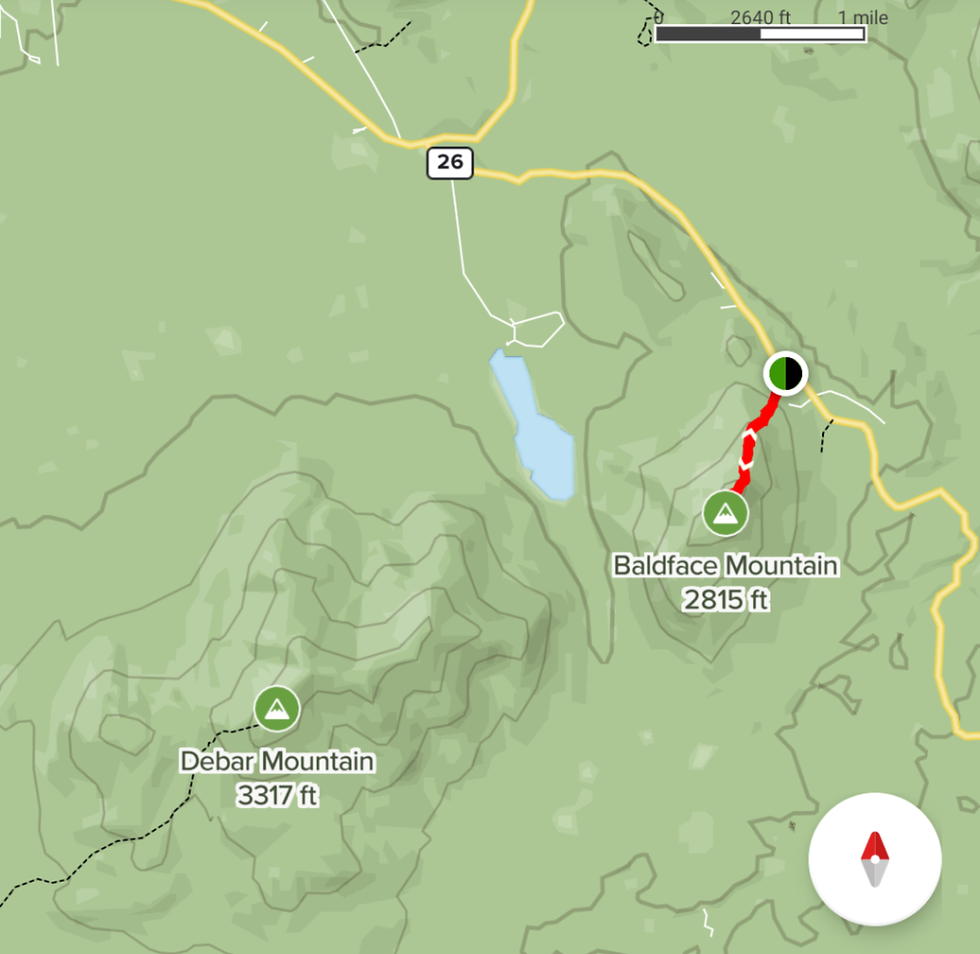
I highly recommend you use some kind of mapping system as there are no signs for this trail. I personally use the All Trails app. The GPS directions feature was spot on with its “you have arrived” message. To be honest, if there weren't any other cars there I may have moved on to one more spot. The only trail marker of any kind is the small 4” face on the side of a tree. I’ve read that during the warmer months there is a trail to follow but this time of year it would be very easy to miss. Baldface Mountain is a steep 1.1 mile route to the summit. It has about 1,037’ of elevation gain in the 1 mile trek.
The forest is pretty thick and I could tell through the 3’ of snow on the ground there has to be many large rocks.

This would make a great autumn adventure, I’m guessing the views would be spectacular with all the leaves in their prime colors. If you want a real outback winter adventure that isn’t too long this is the spot for you. I did find a few pieces of surveyors tape along the way. As I look back I have to assume it is there for the backcountry skiers and snowboarders to mark out steep cliffs on the other side. Kind of a “don’t go this way” marker. If you approach from the west like I did, know that the fastest way back to civilization is to turn around and go back the same way. If you choose to continue south east on 26 it is a long haul to the next main road. I chose the long way just to see what was out here. I was impressed with all of the snowmobile trails and the many DEC signs for different locations to explore. I will definitely make this drive again just to see everything that is out there to discover. This road eventually winds around Loon Lake and over to Route 3. From this intersection you are about 15 minutes from Saranac Lake. I chose to go through Saranac Lake on my way home and I was impressed with all the activity going on. The main street had lots of people out walking around. Stewart’s had many snowmobilers fueling up and getting snacks. Driving by the hospital, Lake Colby was filled with ice anglers. I’d say there were well over 100 people out there. It was great seeing all these people out creating their own Northern NY Adventures.
Aaron Hardy
Northern NY Adventures


loved it....felt like I was on the trail.